


Fox4, photogrammetry solution UAV
بيجويتيري والهواية
المجوهرات - المجوهرات - بيجويتيري
وصف المنتج
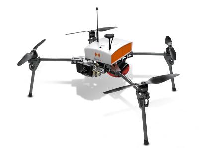
Fox4, photogrammetry solution UAV;
Its light structure and engine allow for extreme maneuverability with manual piloting. Designed for automatic photogrammetry missions up to 1.5 km², Fox4 may also carry out missions for inspection of infrastructure, structures, network lines or industrial sites, in automatic or manual mode. Perfect for your daily mapping missions and calculations of cubature, this quadcopter allows for photo collages, georeferenced orthophotos and point clouds as well as DTM / DSM. This drone is made for professionals of the measurement such as surveyors, topographers, archaeologists and responsible for quarries or mines.
مناطق التجارة
منتجات

FR
بيجويتيري والهواية, المجوهرات - المجوهرات - بيجويتيري

FR
بيجويتيري والهواية, المجوهرات - المجوهرات - بيجويتيري

Copyright Netetrade 2025. Developed by Yartu Labs