


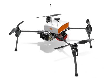
Fox6, multirotor drone for accurate topography
بيجويتيري والهواية
المجوهرات - المجوهرات - بيجويتيري

وصف المنتج
Fox6, multirotor drone for accurate topography;
Its solid structure and in-flight stability allows its use on a wide variety of sites. Fully automatic, the Fox6 can carry out photogrammetry missions of up to 1.5 km². It is the perfect tool for large scale mapping missions as well as for static work and volume measurements. Thanks to its HD sensor and compatibility with DroneBox RTK, the Fox6 provides high precision for georeferenced photo collages, orthophotos, point clouds and DTMs / DSMs. This drone is made for professionals of the measurement such as surveyors, topographers, archaeologists and responsible for quarries or mines.
مناطق التجارة
منتجات

FR
بيجويتيري والهواية, المجوهرات - المجوهرات - بيجويتيري
FR
بيجويتيري والهواية, المجوهرات - المجوهرات - بيجويتيري

Copyright Netetrade 2025. Developed by Yartu Labs